Fire map aids homeowners with insurance
Published 12:00 am Tuesday, July 27, 2010
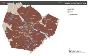
- Click here to see a larger version of this map of areas in Warren County that are more than five miles from a fire station. (pdf file)
More than 2,000 people in Warren County live more than five miles from a fire station, which can lead to insurance rates of up to 30 percent higher than those who live closer to stations.
The City-County Planning Commission generated a map showing those areas and distributed them to the chiefs of the nine county volunteer fire departments.
“Insurance companies were using MapQuest or Google Maps to route how response would be,” said Steve Hunter, executive director for the planning commission. “We re-mapped it and said this is what is official for Warren County.”
Now, when people get a quote from an insurer, they can take the map with them to show that their property is within the five-mile mark.
Hunter and others were quick to point out that all of the county is covered by a fire department, and the five-mile holes relate only to Insurance Service Office ratings.
The Insurance Service Office provides risk analysis for many insurance agencies, which helps to determine rates. One factor that plays into ISO ratings is driving distance from a fire station. Once a house is beyond that five-mile mark, rates jump.
“That does cause problems,” said Chris Wiseman, of Blake, Hart, Taylor and Wiseman Insurance Agency. “Some insurers do not feel comfortable quoting a price for those homes because the price increases pretty significantly.”
Wiseman said he doesn’t see this problem too often, but when it happens it can be difficult finding a good price for customers.
The biggest hole on the new map is still in the northern part of the county, with a few other areas on the periphery of the county.
Terry Young, District 6 magistrate, represents the area with the biggest gap.
“I’m very interested in getting another substation in the community to help those folks,” Young said. “Nobody’s been irate about it, but they are very much interested in getting included in that five-mile (coverage).”
Young said he is working with the Richardsville Fire Department, which covers about 126 square miles, to further eliminate the holes in the map.
“We are trying to get everyone in our districts the cheapest insurance they can,” said Kevin Greathouse, coordinator for the county’s fire departments.
For some of the houses on the border, Greathouse said some fire departments will drive several vehicles from the fire station to the house. They’ll take the average mileage of those trips to see if the house might actually be at or less than five miles away.
Recently, the Richardsville Fire Department built a substation at Ky. 185 and Anna-Sandhill Road, closing several gaps, and Warren County Fiscal Court is looking at other ways to bring more of the county under the five-mile blanket.
“We continue to work for better training, and to fill the gaps in coverage to lower the ratings. And we are planning to build additional substations wherever economically feasible,” Judge-Executive Mike Buchanon said in an e-mail.
The Anna station took more than eight years to be fully realized, according to Young. Young said he realizes new stations won’t come overnight.
Some of the approximately 89 square miles in the county not within five miles of a station is either a flood plain or farmland, and the cost for bringing it in can’t be justified. And not all insurance companies use ISO ratings.
State Farm uses its own data for calculating home insurance, said Ralph Dillihay, a State Farm spokesman.
“Distance from a fire station, whether it’s three miles or six miles, doesn’t make a difference with us,” Dillihay said.
If a house was extremely far from a fire station – for example, 20 miles – then State Farm might choose to just not insure the home, according to Dillihay.
“It’s more of an eligibility issue,” he said.