NWS confirms single Butler-Warren tornado, surveys continue in Logan, Simpson
Published 1:45 pm Tuesday, May 28, 2024
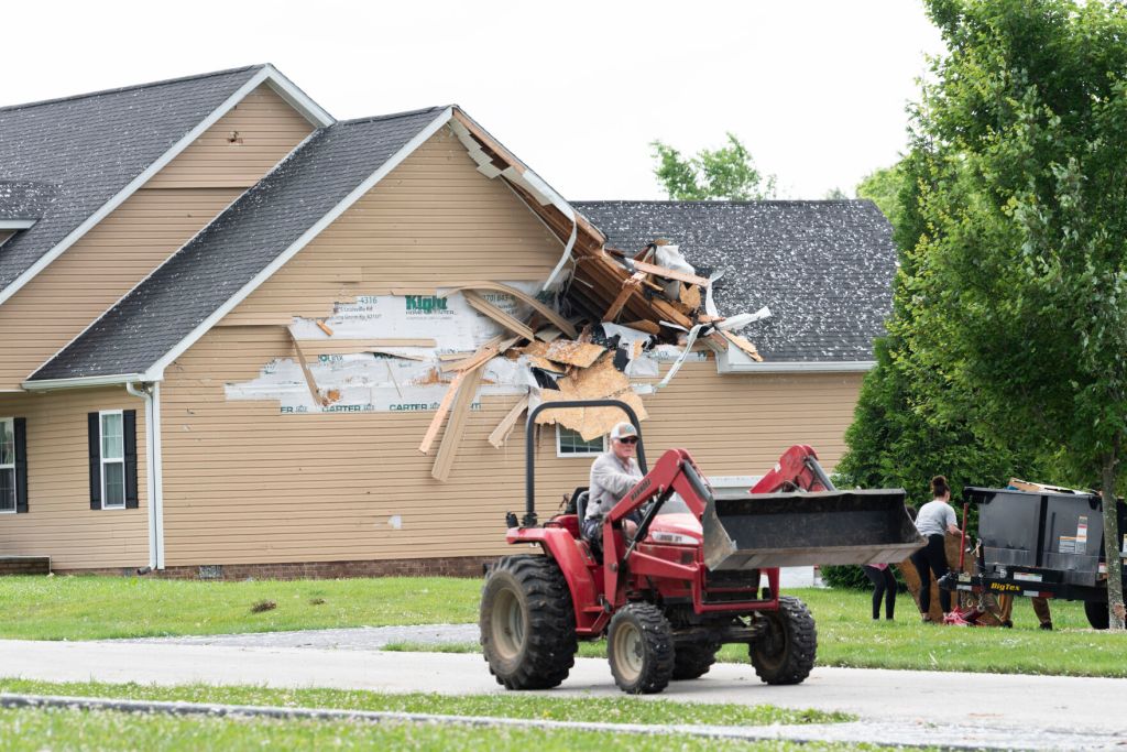
- The area of Allen Michael Lane near Richardsville was damaged during Sunday night’s storm.
Storm survey teams confirmed the tornado that struck Butler County on Sunday also traveled to north Warren in a continuous track roughly 30 miles long.
Teams from Louisville’s National Weather Service station and other organizations concluded Monday afternoon the tornado touched down near the Butler-Muhlenburg line and traveled east to north of Plum Springs.
NWS Louisville Meteorologist Samantha Michlowitz told the Daily News the tornado is preliminarily rated as an EF-1 with wind speeds of roughly 110 mph, though considerable damage consisted of EF-0 wind speeds between 65 to 85 mph.
“In the north and south extent of that tornado path, there’s a lot of EF-0, but we do have a good bit of EF-1 specifically in the Plum Springs and (Mount Olivet Road) area,” Michlowitz said. “There was some considerable damage there.”
She said the Sunday night storms were a “significant weather event” with downed power lines and trees across NWS Louisville’s entire central Kentucky service region.
“Pretty much every single county had at least a tree down,” she said.
Thousands remained without power Tuesday, with Warren Rural Electric Co-Op Corporation reporting 2,200 members without electricity at 12:15 p.m, down from a high of approximately 13,900 on Monday morning.
“We have 35 additional crews on the ground this morning, working 213 outages and 97 broken poles,” the company stated on X.com.
Bowling Green Municipal Utilities reported on X.com at 8:30 a.m. 19 outages impacting 259 customers.
Warren County Judge-Executive Doug Gorman said it has been a busy few days since the storm for emergency management, road crews and parks staff working on cleaning debris and repairing power lines.
Gorman issued a State of Emergency in the wake of the storm, which destroyed almost 100 utility poles and damaged property across north Warren, he said.
“We’re obviously very blessed that there wasn’t a loss of life,” Gorman said. “That’s one of the most important things to us, obviously, but we still have a lot of power that’s out.”
Gorman advised continued caution to anyone traveling through north Warren near Plum Springs, Richardsville and Hadley where debris may still be present and road crews are still active.
“The community just needs to be paying very close attention to emergency personnel but also utility personnel that are traveling on the roads,” Gorman said. “We still have a lot of a lot of cleanup to do and a lot of work we’re doing and we just don’t need to have extra traffic out there if it doesn’t need to happen.”
He added the timeline for clean-up efforts is not clear but the county government is working with state and federal agencies to facilitate the work.
“We have a responsibility to do the things that we can do, but I think it’s great also that we’re already seeing neighbors helping neighbors,” Gorman said. “That’s what makes our community great.”
NWS Louisville has so far confirmed two tornadoes across Kentucky, including another in Meade County, and conducted surveys in Logan, Simpson and Mercer counties throughout Tuesday.
“In Russellville’s downtown, there’s quite a bit of structural damage to some businesses and buildings down there, and the county emergency management called us and asked for a survey,” said Michlowitz. “Based on radar, there could have been a circulation, but a storm survey will confirm that or not.”
Other storm damage surveys are planned across eight counties this week, Michlowitz said, including Barren, Metcalfe and Monroe.
“It’s going to be quite busy here,” she said.


