NWS confirms Bowling Green tornado, recovery ongoing in Logan County
Published 8:00 am Wednesday, December 13, 2023
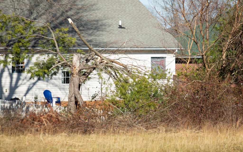
- A tree on Cave Springs Avenue in the Fieldstone Farms subdivision off Three Springs Road stands snapped in half on Tuesday, Dec. 12, 2023, as clean-up and recovery efforts continue since last weekend’s tornado in Bowling Green that the National Weather Service’s Louisville office rated as an EF-1 with wind speeds up to 90 MPH. (Grace Ramey/grace.ramey@bgdailynews.com)
The National Weather Service’s Louisville office confirmed one tornado touched down in Warren County during last weekend’s storms, coinciding with a tornado that swept through parts of Tennessee before crossing into Todd and Logan counties.
Bowling Green’s tornado was rated as an EF-1 with wind speeds up to 90 MPH. It damaged homes, businesses and utilities in south Bowling Green around Three Springs Road, according to NWS Louisville.
Trending
The tornadoes nearly coincide with those that touched down on Dec. 11, 2021, leveling large parts of Warren County.
The report states the latest tornado picked up speed as it traveled over two miles roughly northeast, at one point spanning 125 yards wide.
“The tornado touchdown was just east of I-165 near Paradise playground,” the report stated. “Damage consisted of twisting and topping some trees, with wind speeds of 80 mph, EF0 and then quickly increased to 90 mph, EF1, with uprooted and snapping trees, roof shingle and soffit damage, destroyed a greenhouse, and uprooting more trees on top of (a) home on Smallhouse Rd.”
The report cited “significant damage” to the Super 8 Hotel and residential structures on Cumberland Trace Road before dissipating between Cumberland Trace Road and Deer Meadow Avenue.
“Many sections of the galvanized roofing structure (of the Super 8) were thrown several hundred yards into the trees and up again against apartments,” the report stated.
A second tornado, which traveled northeast for almost 43 miles before lifting in Logan County, peaked as an EF3 in Tennessee and later shifted to an EF2 after crossing state lines.
Trending
The report from NWS Louisville stated the tornado at its peak in Logan County stretched 250 yards wide, with wind speeds estimated at 115 MPH. It traveled approximately 18 miles through Logan County south of Russellville.
“A well-built two-story house sustained extensive roof damage, had its foundation shifted, windows blown out, 3 vehicles thrown and severely damaged, and 2 barns destroyed with impalement of barn boards,” the report stated. “Debris was thrown several hundred yards from the north to the east southeasterly direction.”
Logan County Sheriff’s Department Sgt. Jason Brent said roughly 40 homes received damage and seven were beyond repair. Brent said, fortunately, he has not heard of any injuries or deaths.
“Homes can be replaced, a loss of life can’t,” Brent said.
He said the damage was largely concentrated in the southwest portion of the county and first responders quickly began searching for trapped survivors.
Brent recalled seeing a home on Watermelon Road that had a large section of roof ripped off. He said within minutes, numerous volunteers with trailers showed up to help recover what they could.
“(The residents) are very fortunate to have close-knit neighbors and friends that would help out,” Brent said. “It was a heck of a response.”
Brent said several organizations are coordinating relief efforts, including the Agape Service Foundation, Red Cross and a Mennonite disaster relief group, and that utilities have largely been returned to working order.
Power lines downed along Highway 100 have already been replaced and Brent said the recovery attention is now mostly on helping those with damaged property.
“As far as I’ve seen so far in my shift today, everything has been replaced and back up and running,” Brent said.
He warned residents that listening to emergency sirens and responding promptly is crucial in severe weather situations and likely helped prevent deaths last weekend.
“When the tones go off to tell you to seek shelter, you really should seek shelter,” Brent said. “It’s not a joke — it’s a matter of life and death.”
In Warren County, Kathy Byrne, a house director at St. Gianna Crisis Pregnancy Home, said a work-in-progress crisis home in the area received structural damage after a “massive” tree fell onto the roof. She said a shed and garage on the property were decimated, the debris of which now litters the property.
“It’s a pretty bad-looking scene right now,” Byrne said.
The home, once complete, will serve as a semi-long-term residence for pregnant women and mothers free of charge, providing food and life skill classes as well as maternity clothes and baby needs.
Byrne said they’ve contacted a tree removal service and will soon begin cleaning up debris with the help of Good Samaritan Ministries of Southern Kentucky, mostly consisting of parishioners from Holy Spirit Catholic Church and St. Joseph Catholic Church, and other volunteers.
Byrne added that around five large trees on the property were uprooted, ripped in half or had branches dangling. She said removing each tree will result in even more debris to clean up.
The organization since April has been working to add an addition to the home for a dining room and classroom for pregnant women and mothers in the home. They’d recently moved the air conditioning unit, which now lays flat on its side.
They expected to open in the spring, which Byrne remains hopeful for, but their timeline now remains uncertain until they can have the damage assessed professionally.
She said donations to help finish the house addition and pay insurance deductibles can be made at StGiannaCPH.org/donate.
No fatalities have been reported in Kentucky, though officials in Montgomery County, Tennessee, and the Nashville Emergency Operation Center confirmed six deaths in Tennessee and dozens more injured.